Society Islands
Society Islands
| Native name: Îles de la Société |
Tahiti |
 |
| Geography |
| Location |
Pacific Ocean |
| Archipelago |
Society Islands |
| Major islands |
Tahiti, Moorea, Raiatea, Bora Bora, Huahine |
| Area |
1,590 km2 (614 sq mi) |
| Highest elevation |
2,241 m (7,352 ft) |
| Highest point |
Mont Orohena |
| Country |
|
France
|
| Overseas collectivity |
French Polynesia |
| Largest city |
Papeete (pop. 131,695 urban) |
| Demographics |
| Population |
227,807 [1] (as of Aug. 2007 census) |
| Density |
143 /km2 (370 /sq mi) |
The Society Islands (French: Îles de la Société or officially Archipel de la Société) are a group of islands in the South Pacific Ocean. They are politically part of French Polynesia. The archipelago is generally believed to have been named by Captain James Cook in honor of the Royal Society, the sponsor of the first British scientific survey of the islands; however, Cook states in his journal that he called the islands Society "as they lay contiguous to one another".[2]

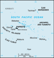
Map of Society Islands
.jpg)
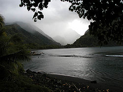
Raiatea
The islands are divided, both geographically and administratively into two groups:
- Windward Islands (Îles du Vent) (listed from east to west)
- Mehetia
- Tahiti
- Tetiaroa
- Moorea
- Maiao
- Leeward Islands (Îles Sous-le-Vent)
- Huahine
- Raiatea
- Tahaa
- Bora Bora
- Tupai
- Maupiti
- Mopelia
- Motu One (Bellinghausen)
- Manuae
The islands became a French protectorate in 1843 and a colony in 1880. They have a population of 227,807 inhabitants (as of August 2007 census).[1] They cover a land area of 1,590 square kilometres (610 sq mi).
References
External links
|
Polynesia |
|
| Polynesian triangle |
|
|
Polynesian outliers and
peripheral cultures |
Anuta · Emae · Futuna · Kapingamarangi · Loyalty Islands · Mele · Nuguria · Nukumanu · Nukuoro · Ontong Java · Ouvéa · Pileni · Rennell · Rotuma · Sikaiana · Takuu · Tikopia
|
|